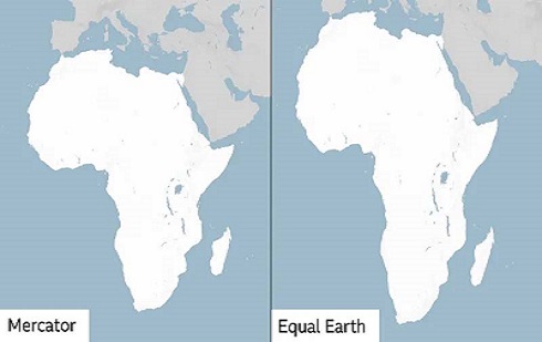
The Mercator projection (Left) is the map widely used across the globe but inaccurately depicts the sizes of countries and continents
HABARI DAILY I Kampala, Uganda I The United Nations General Assembly has voted overwhelmingly to support a new world map designed to give Africa a more accurate representation of its true size, challenging a centuries-old cartographic system that has long made the continent appear smaller than it really is.
The “Correct the Map” resolution, sponsored by Togo and backed by all 55 member states of the African Union, was adopted on Friday, September 4, 2026, after 164 countries voted in favour. The United States was the only country to vote against the measure, describing it as “superfluous”, while six countries abstained.
At the heart of the resolution is the push to move away from the Mercator projection, the world map that has been widely used since the 16th Century but significantly distorts the relative sizes of landmasses.
Distorted representation
On a conventional Mercator map, Greenland can appear roughly comparable in size to Africa. In reality, Africa is about 14 times larger than Greenland.
The distortion results from the challenge of representing the spherical surface of the Earth on a flat piece of paper or screen. The Mercator projection, developed in 1569 by Flemish cartographer Gerardus Mercator, was primarily designed to assist European navigators by preserving directions and making ocean navigation easier.
However, its usefulness for navigation came with a major visual consequence: areas closer to the poles appear much larger than they actually are, while areas around the Equator appear relatively smaller.
That distortion has increasingly attracted criticism because Africa, which straddles the Equator and covers about 30.3 million square kilometres, is visually diminished when compared with Europe, North America and northern territories such as Greenland.
Supporters of the new map argue that this is not simply a technical issue for cartographers but one that influences how people understand the world.
Togo fronted vote
Togolese Foreign Minister Robert Dussey, whose country sponsored the resolution, captured the argument ahead of the vote by saying: “A fair world begins with a fair map.”
Dussey had earlier told a UN briefing that maps influence people’s understanding of their place in the world.
“A map is never neutral. It shapes perceptions, influences how the place of peoples and continents in the world is understood,” he said.
The resolution promotes the use of the Equal Earth projection, developed by a team of cartographers in 2018 as an equal-area alternative to projections that exaggerate the size of countries and continents near the poles.
Unlike the Mercator projection, Equal Earth seeks to preserve the relative areas of landmasses. Africa consequently appears much closer to its actual proportions, giving viewers a clearer sense of the continent’s enormous geographical scale.
The UN vote therefore represents a major symbolic victory for African countries that have campaigned for greater accuracy in how the continent is portrayed internationally.
Beyond geography, proponents say the change could challenge longstanding perceptions about Africa’s scale, economic potential and development needs. Critics of the Mercator projection argue that visually shrinking Africa can contribute, even unintentionally, to an underestimation of the continent’s geographical importance and resources.
The resolution is, however, non-binding. It does not immediately force governments, schools, publishers, technology companies or international organisations to discard existing maps.
Map to reflect world
Instead, it establishes international support for a shift towards representations that more accurately communicate the relative size of the world’s continents.
The significance of Friday’s vote therefore extends beyond replacing one map with another. It marks an attempt by the international community to correct a visual representation that has shaped people’s understanding of the world for generations.
After centuries of looking at a distorted world, the UN vote sends a simple message: the map of the world should reflect the world itself.